Talk about GIS, Photogrammetry, Point Clouds and Orthomosaics, and you've lost the majority of people. Mention drones and they understand (or think they do). Nerdy, geeky nuisance buzzing around invading everyones privacy.
A drone will play a crucial role in this story, but right now I think it's about 20% of the story, if that.
Think of that epic blockbuster at the cinema that everyone's talking about... you don't talk about the cameras do you, but we wouldn't have films without them.
While we're on the subject, I've always wanted a drone... of course I have, they're pretty cool (sorry). But i've never been able to justify buying one. Fly around, take some cool aerial photos, put it back in a box and forget about it.
But now, with a new outlook on GIS, I may have a reason.
I've worked in the construction industry for 30+ years. Design side, working with intelligent 3D models. I know about buildings, coordinates, measurements, data, parametrics and so on.
I also love the outdoors. Fresh air, peace and tranquility, nature at its best.
A little while ago, I spent six months as a volunteer with Forestry England. Part of my time there was spent using their GIS software. Technology combined with nature - perfect. It was my first real insight to GIS software, and I loved it and wanted to do more with it.
Capture my own data
Worthwhile causes...
I mentioned at the start, that I was looking into a voluntary role, and that in part led me to this GIS mission. Well it's worth just reflecting on that briefly...
I like a good cause, a worthwhile effort, doing something for the benefit of others. If I went back in time, maybe i'd be a Fire Fighter.
Worthwhile things that interest me these days include:
- Police
- Fire
- Search & Rescue
- Forestry
- Agriculture
And all of these benefit from hugely from technology, including GIS and of course drones. This is partly why I plan to eventually follow the RPC certification route.
Using QGIS to combine a large quantity of GPS trails, as captured by my Apple Watch.
I was determined not to just have some ideas and rush out to buy an expensive drone. I'm now about six weeks into this 'project' and still haven't clicked the add-to-basket button. However I have done a tonne of research, and learnt loads.
A significant amount of these projects will involve processing imagery and turning aerial photos into terrain maps and so on. So understanding the process and the software is crucial.
It took me a week or more to research and understand just the basics, and to get to the point where I knew enough to experiment. As with all these things there are many ways and different workflows suit different scenarios. For me, I’m sticking to free or very low-cost options for now, and I have only average computing power available at the moment.
To cut a long story short, the most common approach is to use WebODM - for beginners like me it’s dead easy to use, but has a tonne of advanced options for those that need them. I don’t fully understand the magic that goes on, but it turns hundreds of photos into meshes, point clouds, 3D models and more.
Perfect? Not sure yet, it needs a lot of processing power especially RAM, so I’m on the edge of it working or not. I’ve tried with some sample datasets and had varying results, but these aren’t really true representations of what I’ll be doing.
I kind of need to get my own data to use (but still resisting that purchase).
When it comes to capturing aerial photography, slow and steady is my plan. I’m not into action freestyle, ducking and diving through caves and tunnels. Nice straight lines in an organised pattern suits me just fine. And that is where Waypoints come in.
Essentially waypoints are a pre-programmed route that you give to your drone to follow. It flies autonomously and you watch it complete the task.
Of course this opened up another vast topic for more research. How do I create them? What are the limitations? Do all drones support them? What settings do I need?
There are multiple websites and apps that make creating these routes nice and simple and I have experimented with several. For now I have settled on Litchi Hub which is great.
So I have started some experimental waypoint routes and begun exploring some of the options. It's also prompted me to try something else in QGIS, which has now become Project 2.
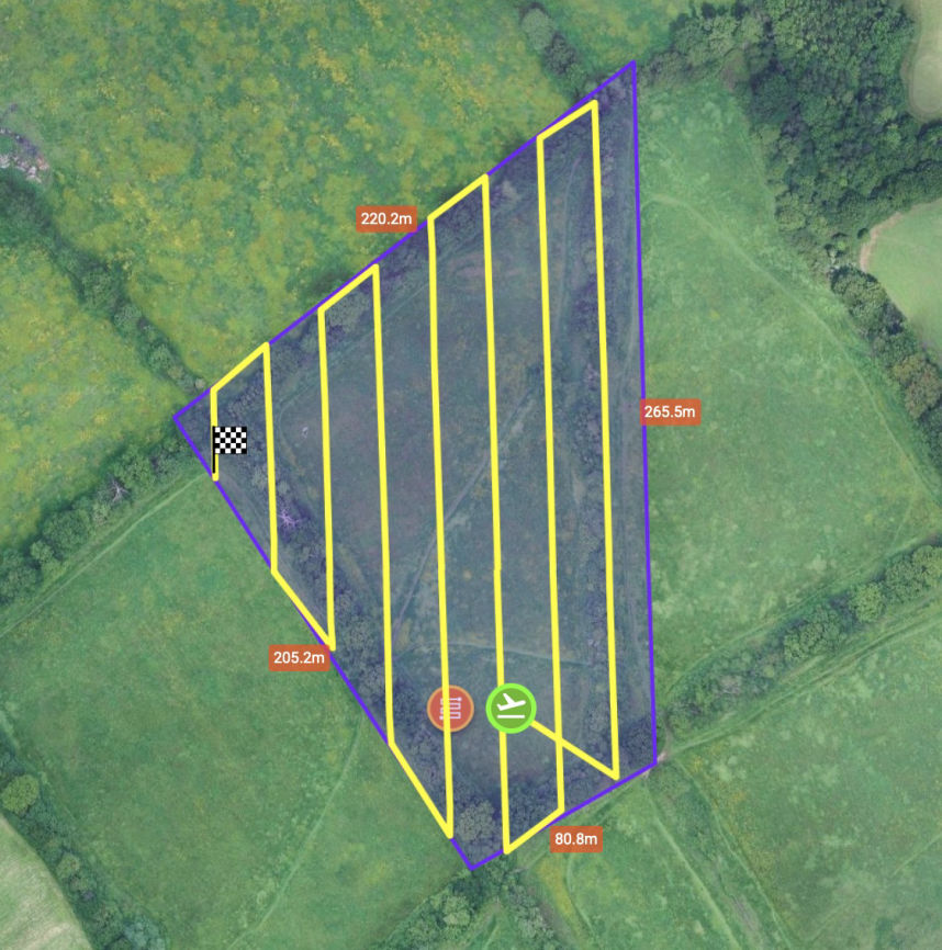
Using QGIS to combine all of my Waypoint Routes automatically, and later perhaps overlay actual flight data.
I'm really pleased with the discoveries I'm making, there's tonnes to learn. Onwards and upwards (literally)!
Mobirise.com